If you do not already know, Singapore’s transport infrastructure is already considered pretty amazing. Travelling around Asia, Europe, and America will slowly open your eyes to how interconnected Singapore actually is. Singapore is constantly fighting for a spotlight on the international stage. For the good things, of course. From our airport to the architecture of our buildings, Singapore spares no effort to achieve the very best that it can.
Singapore is not particularly known for its transport infrastructure per se. But in comparison to other first world cities, Singapore can definitely hold a candle to the best. The LTA Master Plan 2040 is aligned with many of the points on URA’s Long-Term Plan. Shorter travelling times, inclusive mobility networks, safer and seamless travelling experiences are all part of the plan.
In this article, we discuss how URA’s Long-Term Plan reviewed in 2022 will help level up Singapore’s Mobility. We take a brief glance at how other first world cities like Paris and Tokyo look like with the bus and train networks. Stringing together a story from the maps of Paris, Tokyo, and Singapore, we take a glimpse into what the future might look like for Singapore.
A Look at Paris & Tokyo
The City of Love (Paris) has a long history dating back 2,000 years. From the Romans, to Napoleon, and now Macron, Paris has seen a long host of leaders and occupiers. War, Literature, Art, Philosophy, Revolution. Paris has been a frontier for all of these in one part of its history or another. People still travel there today to witness the spectacular Gothic architecture of historic churches, and visit the museums which host a range of art from the Renaissance to Impressionism.
Tokyo is very similar in some ways, with over 3,000 years of human history. It was previously named Edo under the Tokugawa Shogunate and has flourished over the past four centuries. Tokyo was also one of the first cities in the eastern part of the world to modernise. Again, Tokyo was also witness to many changes across time. Shifts in power, art styles, ways of thinking and living. While we aren’t going deep into Modernisation Theory or particular bits of history, setting the context of these two cities is important when we consider how they have built their transportation infrastructure.
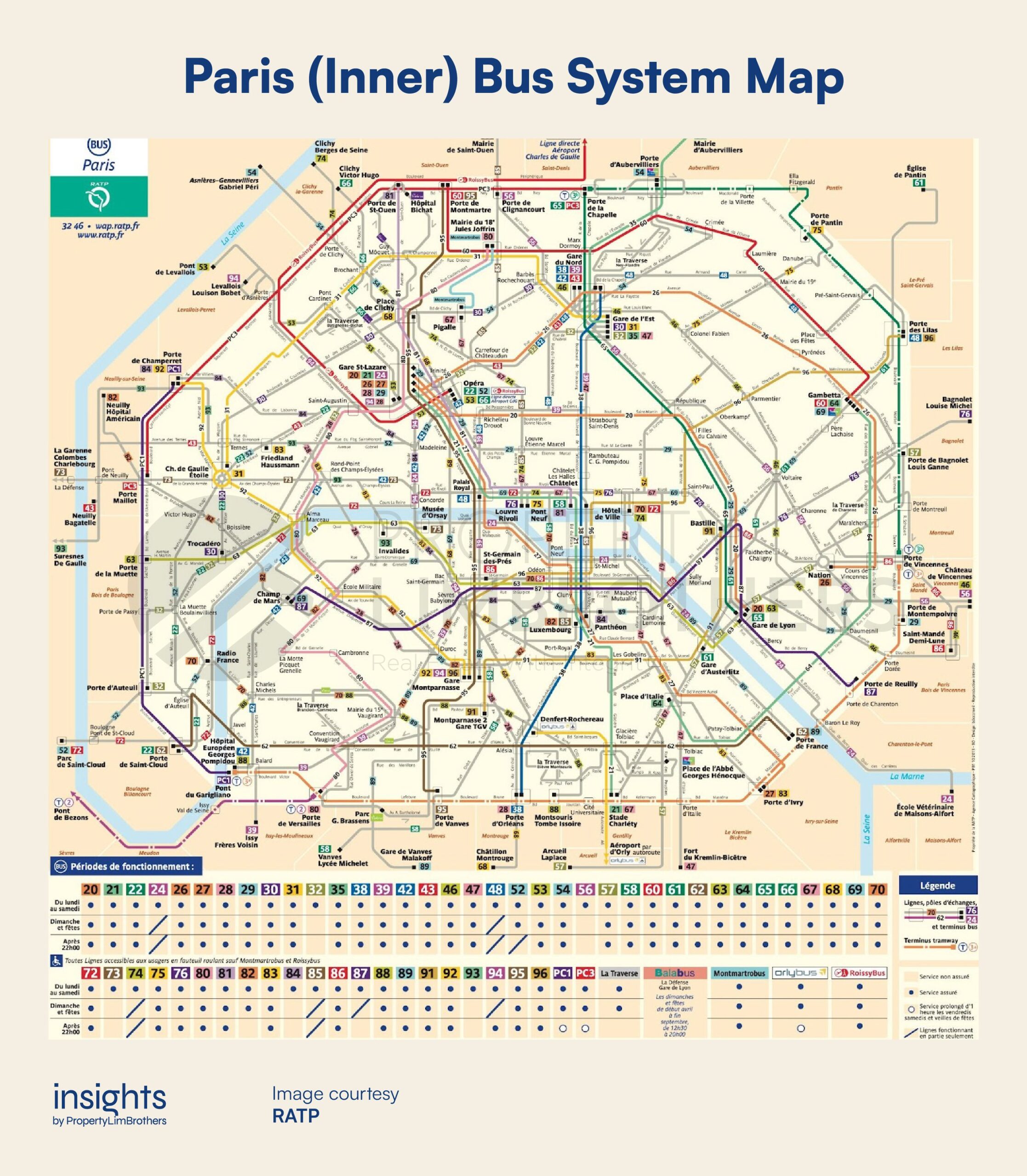
Looking at the bus maps of Paris (above) and Tokyo (below), we can start to appreciate the colourful and plentiful bus services that operate in the city. For additional context, Paris spans 105.4 kilometres square while Tokyo makes up a total of 2,194 kilometres square. Paris has over 70 bus services (under RATP alone) across the city itself and another 200 services that help to connect the city with its suburbs. This is served by over 9,500 buses. Paris’ average user waiting time for a bus is around 12 minutes. These maps are just a portion of the inner city bus services. It would be way too difficult to read with all bus services crammed into one map.
On the other hand, Tokyo has over 200 routes under Toei Bus with over 1,400 buses. But has almost 21 times more area to cover. What’s more, an important feature of buses in Japan is their “non-step” buses, which are friendly to the elderly, handicapped and less-mobile individuals. Most of Singapore’s buses also have this feature.


Looking at the train maps from Paris and Tokyo might be a sneak peak into the future of Singapore. How many lines would we end up having? Probably as much as they can build. In Paris, most of the city is accessible via their metro system, with stations located a short walk away for most venues. Paris has a total of 16 metro lines with 308 stations, Tokyo has 13 metro lines with 285 stations, Singapore has a total of 8 metro lines with 187 stations.
More may not necessarily be better when it comes to expanding metro lines. Rail infrastructure is expensive to build, and even more difficult to repurpose and remove if they are underutilised or defunct. The marginal returns from building more and more metro lines quickly diminish once you’re past a certain level of connectivity. How much then is considered to be excessive?

Not only does it cost a bomb to build and maintain subway networks, it might also be overwhelmingly complicated for passengers. Without the help of Google Maps or other navigation software, most travellers (tourists especially) might find themselves lost or spending even more time figuring out which path is the fastest way to their destination.
Thus, it is also important for transportation planners to look at how clear the system is. And whether each new addition to the system purposefully adds value to its users. Will Singapore’s transportation system grow to be something overly complex? Or will it help travellers meaningfully reduce their transit time with a more pleasant and safer experience?
Singapore, with its relatively shorter history, has the privilege of being able to plan and work with less legacy systems. With the additional leeway to build and develop without having to actively conserve large amounts of history in the form of buildings. This has definitely helped the city planning go in a more streamlined manner.
Singapore’s Mobility Focus
Singapore has a land area of 728.6 kilometers square. Compared to Paris City (105.4 kilometers square) and Tokyo City (2,194 kilometers square), Singapore lies somewhere between. Each city has its own objectives and method in city planning and how they design a transit system. For Singapore, its long-term focus is to create a comprehensive, well-connected, and efficient transit system for passengers and businesses of all kinds.
Having a big goal is compelling in its own way. Being able to coordinate efforts with other government agencies in an aligned manner is even more impressive. URA’s Long-Term Plan for mobility in Singapore works across multiple different bodies. LTA and NParks are two such examples, and are indispensable in order to effectively realise this goal.

Adding cycling paths (map above) across Singapore is one of the key thrusts of the decade. The Park Connector projects along with the Rail Corridor shows how mobility also goes hand-in-hand with healthier living. To the URA, all these aspects of development are interlinked as mentioned in our introductory article on the Long-Term Plans.
While the sweltering heat in the tropics might dissuade some people from cycling as a main means for transportation, the cycling paths nonetheless complements conventional roads and train systems. Cycling paths can also be used as footpaths for walkers. Although on this point, safety has always been a concern for shared cycling-footpaths. With the decentralisation of the CBD and the movement to have more commercial modules closer to heartland homes, such as the Jurong Lake District, The already noticeable increase in the cycling community may grow further as we take a greener approach to ease road traffic congestion
It has been highlighted in the Long-Term Review that such paths would help with a more active lifestyle for residents. More greenery will also be integrated into space to make the outdoor experience more enjoyable.

Transit Priority Corridors (TPCs) prioritise buses, footpaths, and cycling paths for enhanced mobility in the neighbourhood. The most exciting addition will be the expansion of the TPC along the North-South Corridor. This will link up Yishun, Canberra, Sembawang, Woodlands neighbourhoods to town. This corridor will also be in line with the environmental focus of going for sustainable means of transportation.
We will be going car-lite, which will probably mean more road space for buses over cars. URA plans to add another 60 km of TPCs by the end of the decade. Residents along this North-South corridor would benefit from prioritised transit to central areas. Singapore has 352 bus routes currently, with over 5,800 buses to (over half to be electric by 2030). The TPCs and bus lanes will help improve the efficiency of buses by mitigating the effects of congested traffic on the public transport system.
By the end of the decade, OCR areas north of town might benefit from this upgrade. Interestingly, the North-South corridor looks like it overlaps with the general direction of the new Thomson-East Coast Line. These two infrastructure developments might have been built with the intention of complementing longer-distance travelling by metro with relevant car-lite infrastructure in the neighbourhoods along the planned TPC.

The current average waiting time for a commute trip in Singapore is around 8 mins. The current transport systems for buses and trains seem to be efficient. Although many were complaining about frequent train breakdowns and delays in the previous decade, the post-covid era seems to have the public’s attention on bigger problems in the world.
With the average waiting time within a rather acceptable range, the rail lines are planned to expand from the west to the northeast and eastern part of Singapore. This is not new. The expansion of the MRT Lines and the addition of new ones have been in the works for many years now. While not many get to enjoy the new MRT Lines especially if they live far away, it is definitely worth exploring.
Singapore’s transport network will continue to grow more well-connected and comprehensive than before. Even though we are not quite at the level of Paris and Tokyo in terms of the number of train lines, Singapore still has an impressive and cohesive transportation network that brings together not only trains and buses but also cycling paths, footpaths. By tying these together with initiatives on being more inclusive and sustainable, Singapore’s mobility is definitely levelling up.
An Exciting & Connected Singapore in the Future
LTA has put up a plan for the upcoming new lines over the next 10 years. While this is not exactly part of the Long-Term Review by the URA, it is definitely motivated by a similar set of goals. In terms of connecting Singapore in an efficient way, the Thomson-East Coast, Jurong Region Line, and Cross Island Line in the future would help to fill in the gaps in transportation.
By having more connection points between different MRT lines (like what the Circle Line and Downtown Line previously did), new additional lines help to improve the traveling experience by providing a more efficient route for users. The Thomson-East Coast line plans to improve the connectivity along the North-South Corridor and complements the current North-South Line (Red Line). Eventually, the Thomson-East Coast line will help connect the central areas to Bayshore, Katong, and Bedok estates.

Having new MRT Lines run parallel to one another like the Thomson-East Coast Line (by 2025) and Jurong Region Line (by 2029) with intersecting Circle Line and Cross Island Line (by 2032) helps to improve the efficiency through a “grid” format. The MRT Map that we see today is an intermediate version. The final form might end up looking as complex as Paris’ or Tokyo’s metro.
The metro system will eventually reach a peak in terms of the amount of new lines they can add. But the authorities are not waiting until then to invest into alternative modes of transportation. For Singapore’s mobility Long-Term Plan, everything is moving concurrently and gradually developing the city into an even more interconnected and faster-paced city.

The Long-Term plan from the URA also mentions some amazing and innovative technologies that we may see in the near future. Air Taxis, Unmanned Aerial Vehicle (UAV), and Autonomous Vehicles are all on the list. Although not much information is given on how and when they will be implemented, we might very well be able to see these new technologies integrated into our lives within this generation.
Express air-taxis to skip all the traffic and queues, drone food and parcel deliveries, self-driving cars, taxis, and buses. These are definitely achievable and implementable realities within the next 50 years. With a forward looking government, such innovation might be able to be implemented a lot quicker and smoother than we think. It won’t be too long before the sci-fi future becomes a reality.
Another important focus on Singapore’s mobility involves international connectivity, focusing on developing our aviation and maritime infrastructure. Singapore plans to extend its position as a global hub and make that position stronger. Logistics infrastructure for delivery services, resource sharing between companies, and specific facilities to aid delivery fulfilment will be developed to help the industry grow.
Closing Thoughts
Levelling up Singapore’s mobility infrastructure is not an easy task. While we do not have as rich a history as Paris or Tokyo, Singapore’s youthfulness has an advantage. The planning and development of new infrastructure can go a lot smoother with less legacy to worry about. A combination of careful planning and thoughtful execution will go a long, long, way for Singapore.
If you wish to discuss how these exciting new developments in Singapore’s mobility will affect your current and future home, please reach out to us here. The fast changing environment and Long-Term Plans will have implications for different locations across Singapore. Contact us to find out how proper planning early can get you ahead in your property journey!


